Case Quality Scores
 This page describes the criteria for scoring the data quality of cases based on how well the geographic entity for which case study knowledge is reported (source data) is described as a spatial unit of Earth’s land surface (case geometry).
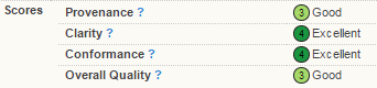
The Overall Quality Score for each case study is the minimum of three scores for the Clarity, Provenance and Conformance of case study geographic descriptions.
To view a visual flowchart of the scoring procedures employed in GLOBE, view the GLOBE Quality Scores Diagram (Margulies et al., in prep).
Case Study Contributors: How to improve quality scores for your case study.
Clarity Score: How clearly is the geographic entity described in the source? The highest scores go to precise geographic descriptions either in maps, GIS files (shapefiles, kml) or precise coordinates.
IF the case contributor is the author/site expert, the text descriptions of the scores in the pull down should read as follows:)
- 4 = Geographic entity conforms perfectly with the data provided in the source. (eg. county data presented for a county, sample point data is for a sample point).
- 2 = Geographic entity conforms roughly to the data provided in the source. (eg. county data are provided for a rough map of the county, data from smaller field plots provided for sample points).
- 1 = Geographic entity does not clearly conform to the data provided in the source. (eg county is the geographic entity, but data are obtained from a non-randomized survey of households in a county).
- 0 = Data provided in the source do not clearly conform to geographic entities that can be described here (eg data obtained from gray literature, expert interviews with general implications at some scale but without any specific geographic entity attached).
IF the case contributor is not the author/site expert, then the text descriptions of the score should read:
- 4 = Geographic entity and geometry fully and professionally described in original source, or correspond precisely to entities for which precise geographic data are available.
- 3 = Geographic entity and geometry are clear in original source, but mapping of the site geometry requires some interpretation before it can be mapped.
- 2 = Geographic entity described roughly in original source.
- 1 = Geographic entity not clearly described in original source.
- 0 = Geographic entity description missing or completely ambiguous
Provenance Score: Reliability of the source of the case geometry. Case geometries entered by experts on the geography of their sites get the highest scores (eg. detailed polygons of a study area entered by an author of the study)
- 4 = Geometry created by author/site expert.
- 3 = Geometry not entered by author/site expert, but a detailed polygon or precise point geometry is used to represent the site.
- 2 = Geometry entered by trained GLOBE team member, but an approximate point geometry is used to represent the site.
- 1 = Geometry entered by a contributor without direct site knowledge, and an approximate point geometry is used to represent the site.
- 0 = Source of the case geometry is unknown.
Conformance Score: Spatial agreement between the geometry entered into GLOBE and the geometry of the geographic entity.
- 4 = Case geometry is entered into GLOBE by uploading a SHP file or an existing geometry is selected, the area of the geometry entered into GLOBE agrees with that reported in the geographic description, and a detailed polygon or precise point geometry is used to represent the site.
- 3 = Case geometry is entered into GLOBE using the map draw function, the area of the geometry entered into GLOBE agrees with that reported in the geographic description, and a detailed polygon or precise point geometry is used to represent the site.
- 2 = The area of the geometry entered into GLOBE agrees with that reported in the geographic description, but the Clarity Score is less than or equal to 2.
- 1 = The area of the geometry entered into GLOBE does not agree with that reported in the geographic description. [test: is the area of the case geometry the same spatial scale as the area entered for the case?]
- 0 = Geometry type is unknown or no data was entered.
These are based on data quality pedigree methods:
Costanza, R., S. O. Funtowicz, and J. R. Ravetz. 1992. Assessing and communicating data quality in policy-relevant research. Environmental Management 16:121-131.
Ellis, E. C., R. G. Li, L. Z. Yang, and X. Cheng. 2000. Long-term change in village-scale ecosystems in China using landscape and statistical methods. Ecological Applications 10:1057-1073.
Funtowicz, S. O., and J. R. Ravetz. 1991. Uncertainty and Quality in Science for Policy. Kluwer Academic Publishers, Dordrecht, The Netherlands.