Combined Land Suitability Class
Citation Information
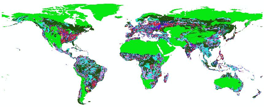
Title: Combined Land Suitability Classes
Source: IIASA Global Agro-Ecological Zones (GAEZ).
Date: 2001
Citation: Global Agro-Ecological Zones (GAEZ). 2011b. Agro-Climatic Constraints. [online] URL: http://www.fao.org/nr/gaez/about-data-portal/agricultural-suitability-and-potential-yields/en/. Accessed June 6, 2011.
Description
Global grid of land suitability for agriculture based on combined climate, soil, and slope constrains constraints. Native resolution is 5 arc minute projected in Geographic Coordinate System WGS 1984.
Combined land suitability classes:
| Classes | |
| 0 | NoData/Water |
| 2 | No Constraints |
| 3 | Very Few Constraints |
| 4 | Few Constraints |
| 5 | Partly with Constraints |
| 6 | Frequent Severe Constraints |
| 7 | Very Frequent Severe Constraints |
| 8 | Unsuitable for Agriculture |
| 9 | Severe Climate Constraints |
Processing Procedure
1. In ArcMap 10.0, convert native data to 30 arc second resolution.
2. Reclassify into numerical classes.
3. Use zonal statistics to calculate mean values within each GLU.
Data Coverage
Data is coded by the number of cells covered by the native data (1), data extrapolation (2), and not covered by either (3).
| DGG Cell Coverage Report | |||||
| Coverage Codes | Frequency | Percent | Valid Percent | Cumulative Percent | |
| Valid | 1 | 1371209 | 94.9 | 94.9 | 94.9 |
| 3 | 73755 | 5.1 | 5.1 | 100.0 | |
| Total | 1444964 | 100.0 | 100.0 | ||