Creating GLOBE’s Global Variables
This page describes how global variable datasets are integrated into the GLOBE system.
Global variables already entered into GLOBE can be browsed as maps.
If you are not capable of geoprocessing a global variable into GLOBE as documented below, you can recommend it for entry by the GLOBE team here, in the GLOBE forum on global variables, or add your vote to a variable that has already been recommended. Variables with the strongest community interest will be added first.
Overview
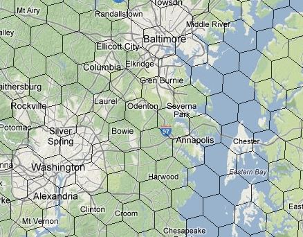
The fundamental spatial units of GLOBE’s global data infrastructure are GLOBE Land Units (GLU), equal area hexagons of about 100 km² (96 km²) each. By stratifying all of Earth’s land into 1.445 million GLUs and computing the value of each global variable within each GLU in advance, GLOBE is able to accomplish real-time global computation and mapping. An example of GLUs covering Washington, D.C. and Baltimore, Maryland, USA is at right.
To compute the values of global variables within GLUs requires different geoprocessing methods depending on the native structure of the global dataset. Specifically, the optimal geoprocessing method depends on the form (vector or raster), type (continuous, nominal, ordinal), native spatial resolution (finer or coarser than 30 arc seconds, smaller or larger than 96 km2 hexagons) and the coordinate system of the global dataset to be processed.
The native form of the GLUs is polygons (vector), but for efficiency in geoprocessing, a 30 arc second raster version of the GLUs is more generally used.
Steps for adding Global Variable Datasets to GLOBE:
- Determine the optimal geoprocessing method to convert the native global variable dataset into GLOBE GLUs.
- Using the optimal geoprocessing method, produce a GLU database for upload into GLOBE:
> Download the appropriate GLU dataset (30 arc second raster, or polygons).
> Use a GIS (we use ArcGIS) to convert the native global dataset and compute values for each GLU.
> Prepare a database in .dbf file format with at least two data fields (columns): The unique code for each GLU (“GLU_ID”) and a field with global variable value for each GLU. The field name for the global variable should be the short, 10 character, name of the global variable. The database may contain more than these two fields, but additional fields will not be used and will increase file size. - Download the percent land coverage file to calculate the area-weighted mean and median values of the geoprocessed global variable. Methods for weighting cases vary by statistics program.
- Download the GLOBE Global Variable Metadata Template (an Excel 2007 ”macro-enabled” workbook). To open this file, it is ideal to use Microsoft Excel 2007 or later, though earlier versions of Excel may be updated. Be sure to “Enable Content” if requested: this file contains a single macro for visualizing map legends: the file does not contain harmful code.
- Provide the requested metadata in the Excel file, including a map legend. Instructions are provided within the Excel file.
- Create .zip file that includes:
A) The completed GLOBE Global Variable Metadata Template.
B) The database file (.dbf) of your processed spatial dataset. - Submit the zip file by uploading it through the Global Variable Forum.
- If you need assistance with the geoprocessing of your dataset into the GLOBE data structure, contact the the GLOBE Team through the forum for assistance.
References
Magliocca, N.R., Ellis, E.C., Oates, T., and Schmill, M. (2013). Contextualizing the global relevance of local land change observations. Working Paper. arXiv:1307.6889


